Park Description
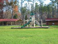
Regional Park with Picnic Shelter, 1/4 mile paved ADA trail, 7 miles of hiking trails, 7 miles of biking trails, playground, 391 acres of natural area. Directions to the park From Hillsborough:
Take St. Mary"s Road east out of Hillsborough. After crossing US 70 continue on St Mary"s for 1.5 miles and turn left onto New Sharon Church Road. Travel about 6 miles to intersection with Guess Road (SR 1003). Turn right on Guess Road and drive 1/2 mile. See park entrance on left." From Durham:
Take Guess Road north out of Durham. About 4 miles north of the Durham city limits, watch for the following landmarks, in order: St Mary"s Road, South Lowell Road, Little River bridge, Bromley Road and the Durham/Orange County line. After crossing over the Orange County line continue driving north for approximately 1 mile and the park entrance will be on the right. From the Raleigh/Cary Area:
Take 1-40 and the Durham Freeway (NC 147) to Durham
From the Durham Freeway exit onto US 15/501 North
From US 15/501 North take I-85 North
Use exit 175-Guess Road at the stoplight at the end of the exit ramp
The park is located 10-11 miles north (after you cross the county line from Durham into
Orange County we are about 1 mile on the right.)
The driveway for the park will be on your right and is marked with a white sign. From Chapel Hill:
Take US 15/501 North to I-85 North
Use exit 175-Guess Road (also known as HWY 157)
Make a left onto Guess Road at the stoplight at the end of the exit ramp
The park is located 10-11 miles north (after you cross the county line from Durham into
Orange County we are about 1 mile on the right.)
The driveway for the park will be on your right and is marked with a white sign.
Chatham County:
Take US 15/501 North to Chapel Hill and continue until to I-85 North
Use exit 175-Guess Road (also known as HWY 157)
Make a left onto Guess Road at the stoplight at the end of the exit ramp
The park is located 10-11 miles north (after you cross the county line from Durham into
Orange County we are about 1 mile on the right)
The driveway for the park will be on your right and is marked with a white sign. From I-70 in Durham/Raleigh:
Take I-70 to I-85 North
Use exit 175-Guess Road (also known as HWY 157)
Make a left onto Guess Road at the stoplight at the end of the exit ramp
The park is located 10-11 miles north (after you cross the county line from Durham into Orange County
We are about 1 mile on the right)
The driveway for the park will be on your right and is marked with a white sign. From Person County (Roxboro) and areas to the north:
Take US HWY 501/57 south to HWY 57 south (look for the BP gas station on your left.) Coming
south you can only make a right onto HWY 57 south. Continue south on HWY 57 until you come to a flashing yellow light (there will be another BP gas station diagonally on your right.) Make a left turn onto Guess Road (also known as HWY 157.) Drive south on Guess Road approximately 4-5 miles. Look for the cross road of New Sharon Church Road and the park entrance is on the left approximately 1/4 mile after New Sharon Church Road.
Hours of Operation: Sunrise to Sunset
Fees:
No entry fees for this park
Metro Region: Triangle, NC
Park Management: County
|